Mawphlang David Scott Trail - East Khasi Hills District, Meghalaya, India, Mawphlang, Synrang Kaban, Meghalaya 793121
Geo Location
Lat long (25.444951,91.7576382)
Mawphlang David Scott Trail - East Khasi Hills District, Meghalaya, India - Featured Reviews (235)
Highly recommended if you are looking for something different amongst all the mainstream falls and view points. This is a beginner-friendly 16km peaceful hike. You will come across villages, cows and local people but very few tourists (we saw only 10 tourists throughout the day).
My wife and I did it on a sunny good weather day in October 2023. We did it in the opposite direction - our driver dropped us at the exit point at Sohra and waited at the entry point at Mawphlang. Took us 7 hours to finish (easily doable under 6 but we took our time)
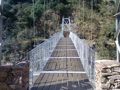
According to my Strava records: if you start from the exit point, there is a one kilometer soft descend and another kilometer of moderate ascend. Then you will cover almost 5km of almost plain land. End of the plain land you will find a village shop with cooked noodles, tea and water. After that you will descend for 3km and cross a river on foot. The trail is not advisable during the rainy season cz you won't be able to cross the river. After crossing the river you will walk for about a kilo and cross it once again but on a hanging bridge. After that you will be climbing the rest of the trail till the entry point - the last climb could test you a bit depending on your fitness level. So overall you will have to climb less and descend more if you start at the entry point.
1. There's no gate or staff at the exit point. But at the entry point local people might force you to take a guide with you. Guide fee is 1500 rupees. You really don't need a guide so feel free not to. The route is pretty straightforward, even at the intersections. At best you could keep the Google map downloaded and follow the general direction.
2. At the entry point you will be asked 500 rupee as 'village development contribution', even if you start at the exit point. This contribution was formally designed as an optional donation - but local people force you anyway - we had to pay it.
3. Carry a water bottle or be prepared to drink stream water along the way.
4. Mobile network is minimal or non existent deeper through the trails
5. This trek is technically beginner friendly but you will get a true sense of Meghalaya no matter how experienced you are.
Worth it overall? YES.
It's a long 16 km hike with exit points at 8 and 12 kms, but you won't even realise that you have completed it. Crossing 7 mountains and 2 rivers, a British era bridge, forests. Seeing wonderful trees and plants and eating Sophie nam....was an exhilarating experience. When I looked back from the mountain top at the distance I had covered, I was awed and had a strong feeling of satisfaction.
Start really early...latest by 8 ...if you want to really enjoy the forest and still complete the trek before dark.
The trekking route was good. The total trekking covers about 16KM. Easy to claim for all ages. There will be a village inbetween the trekking route, where we can rest. Most of the routes are straight plains.
Amazing!!!
It's a 16 km long trek. Need to carry light food and water. You can refill your water bottles with the waters of the natural streams which is absolutely pure. After completing about 12 km you will get a small village where you will get Maggie and tea. Do not visit on monsoon season as you will not be able to cross the river. You will experience beautiful landscapes which you will not get to experience by car
It was my first trek. I was not sure if i will be able to do it but my batchmates cum friends give me confidence that i can do it and I did it. Coming to the trek points. It was a great experience. The entire trek is very beautiful.
Some parts are nice, especially the first hour untill you pass the first river. However the forest along the path from there ahead is very degraded. It is either very young or completely destroyed. On two sections we actually saw deforestation in process, local people cutting and burning trees only 10 or 15 years old. Such a shame.
Trekking with a great view.
6 hrs trek if you are planning to return back to the starting point. Make sure you carry enough water with you since climbing back up can be a bit exhausting(depends on your experience level). If you are not planning climbing back up then you can continue till you reach Sohra.
Before climbing down and starting your journey don't forget to visit the view point which is on the left hand side path (the right hand side path is the trek). Watching sunrise from the viewpoint is something else.
The trek has transported me to a different world, walking at my own pace devouring the ever-changing landscape of forest cover. Hanging wooden floor Bridges. Though, we didn't complete full trek, but absolutely mesmerising experience.
Cons- At the start of trail locals force to hire a guide, even if you didn't want any you'll have to pay for that also. Rest nice place for second try!
Frequently asked questions About Mawphlang David Scott Trail - East Khasi Hills District, Meghalaya, India
Where is Mawphlang David Scott Trail - East Khasi Hills District, Meghalaya, India Located ?
Mawphlang David Scott Trail - East Khasi Hills District, Meghalaya, India Located in Synrang Kaban of East Khasi Hills. The complete address is Mawphlang David Scott Trail - East Khasi Hills District, Meghalaya, India, Mawphlang, Synrang Kaban, Meghalaya 793121.
Is there any website for 'Mawphlang David Scott Trail - East Khasi Hills District, Meghalaya, India' ?