Q662+VX4 Rajghat Dam, Rajghat Dam Rd, Kunwarpur, Madhya Pradesh 473446
Geo Location
Lat long (24.7621296,78.2024535)
Rajghat Dam - Featured Reviews (54)
The reservoir is huge. At some points, you can't see an end. The sunset as well as full moon looks lovely through the water. The view from a place ahead of the dam is better. You can take the parallel road towards Chanderi to reach a decent view point.
It's a connecting road nd dam of MADHYA PRADESH nd UTTAR PRADESH ...
It connects chanderi rajghat road to lalitpur jakhora road ..
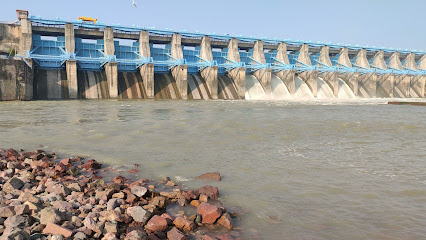
In rainy season you can easy see 2-3 gates of dam are open ..
Nice connectivity ...
Go for it ...
Rajghat dam is a very famous and big place of lalitpur distrct UP. This is Great osm view to See. Very people goes to its Glorius moment in Summer season. This dam is very helpful to the man of this District.
Beautiful and tourism place, amazing nature view .
There is a very large water storage dam. Very beautiful views can be seen from here
The foundation stone for this modern monument was laid by Late Smt. Indira Gandhi in 1971. Located on the border of the states of Uttar Pradesh and Madhya Pradesh, it is built upon the Betwa River. The catchment area formed by the dam is around 17000 square kilometres, which had led to the submersion of around 70 villages.
Three canals distribute water from the dam out of which two supply water to Uttar Pradesh while one supplies to Madhya Pradesh. Three turbines of 15 megawatt each are installed to produce electricity.
The length of the sand barrier constructed is more than 11 kilometres, which is longest sand barrier in any dam in Asia. The cement dam is 600 metres long and 73.5 metres high. Ancient villages, such as Panchmnagar, Bari, Toda, Sirsaur, Naredi were lost to the water and the sculptures recovered from these places have been collected in the Ramnagar Palace Museum.